Friday, October 28, 2011

Footpath Surveys From The Cold Fell Road

Many of the Ennerdale footpath surveys are from the Cold Fell Road which has just re-opened after a 4week closure so we took the opportunity today to start some of them. We were last up here in May when they were actively felling here, today it was quiet but the landscape was quite dramatically changed. There is still a lot of wood to collect from up here
You now get clear views to the summit of Grike
And across Kinniside Common
The clouds just resting on Pillar in the distance
Still plenty more trees to be felled here
Soon we are heading to the final gate on this footpath with glorious views of the Ennerdale valley
On our way back new views of Dent & Egremont to the left. You could also see the Isle of Man in the distance although the camera couldn't quite pick this up
Dent with Cleator Moor to the right
This is the new forest track that has been built for the logging waggons
Zooming in on Frizington Quarry

Thursday, October 27, 2011

A Few Ennerdale Pictures

Just a few pictures from the footpath surveys Karen did on Tuesday (Andy was tree planting). Before we started we checked the wildlife cameras but have only managed to prove the Galloway cattle are in the valley & that the date & time are set wrong on the camera! We then walked further into the valley, looking up at Pillar
It's sunny at the other end of the valley
We walk up a footpath that takes us close to Scarth Gap & then down another to Black Sail where some of the Galloways were gathered.
Autumnal colours in the valley
This hut is new it is the new hydro electric scheme in Gillflinter Beck that powers High Gillerthwaite Youth Hostel
Despite over 4hours of walking & a reasonable climb Crag still wants to play with sticks, the bigger the better!

Monday, October 17, 2011

Archeology in Ennerdale valley.

Last Friday Andy met up with 5 other volunteers to check up on some of the archaeological sites in the valley. We planned to walk along the southern lake shore and locate as many as possible using information supplied by Gareth from the Forestry commission.
The first site was a bit vague and could have been the site of a potash kiln but like a lot of things looked at that day much of it is only supposition as they have not been properly investigated, there are several hundred sites in the valley so not surprising.
The next one was a short distance to the east but above the path, they are not sure what its purpose is as its quite small, there was a suggestion that it could have been a medieval chicken coup!!
We moved on to the other side of Anglers Crag to the site of a medieval Bloomery, this is where iron ore was smelted.
Peek a boo
This is the actual mine site, surprisingly only 10 metres away from the bloomery. Talking to locals they have always assumed the mine site was much further up the fell.
The comment about the next site was that if we cant find it we might as well go home. Well we had lunch about 15 metres away and we searched for about 20 minutes before it was found on the lake shore. Some of the descriptions and gps data wasn't accurate. This was also part of our brief to accurately locate the sites.
This one was described to be to large for a sheepfold but may have been a dwelling. If the lake has risen this is possible but if not we came to the conclusion that it could have been a dock/harbour, well its a good guess as any!
Continuing further east the next one was described as another potash kiln or possible a bothy as it had a chimney.
The last site we looked at was another bloomery, this picture is of the slag heap where it is estimated there is 1.5 tons of slag.
The bloomery
We again had trouble finding this site. The info we had said there was a crab apple tree on this site and there was slag in the stream bed. There were several streams running through the site and we eventually found the slag very close to the lake side where it had been washed down. As to the tree there were a few that had fell down but the slag heap was next to a very old HOLLY tree, obviously Archaeologists not Botanists!
A good day out and many more sites to discover.

Footpath Surveys by the River Liza

Last Thursday we were back doing some more footpath surveys in Ennerdale. We parked at Gillerthwaite & headed off on a loop of part of the valley. Not many pictures as it is an area we are very familiar with. We walked the Liza path which our work parties have spent a lot of time clearing & bettering the drainage. This however is a bigger problem than we can tackle with the tools we have. The damage was done in November 2009 & you can see from this picture taken in Feb 2010 that the water levels in the beck have further shifted the bridge The continual erosion by the River Liza means this island many not be here for much longer as you can see the water pouring through it.
The dogs enjoy a play whilst we have our lunch
Andy clears this drain of leaves, the dogs think it is a game to catch them as they fall
It wasn't the longest walk, but by the evening: JOB DONE!

Saturday, October 08, 2011

Footbridge Surveys in Eskdale

Earlier in the week we had been asked if we could help out with 7 footbridge surveys in Eskdale. When we received them we found out they were in two close groups of 3&4. We parked up below Stanley Falls but headed east into the valley. 
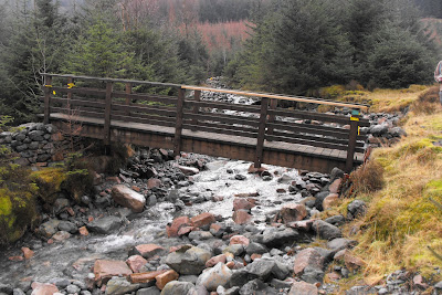
The beautifully clear River Esk This is the first bridge, it serves little purpose as no water flows under it
Then the more impressive Girder bridge over The Esk
Is this really a bridge?, we checked the area & it was the closest thing we could find within the grid reference
Then we drove the short distance to the next four in Mitterdale
We think this is Cumbrian for "Head Right For Eskdale"
The next bridge, unusual as the handrails are metal
Heading further into the valley with Sca Fell in the distance
We then come to this derelict building which was once Bakerstead Outdoor Pursuits Centre
But it looks as if it may not be derelict for long as a track to give vehicular access to it is being built
It is quite a big building which is in excellent condition
The footbridge over The River Mite
These old farmhouses at Mitterdale Head have seen better days, that tree is growing out of the walls, looking like an aerial sticking from it
And the last one is a very old bridge, its a shame that the surface has been tarmaced